


Tour B 5ème jour

berlage
User
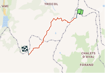

Length
8.2 km

Max alt
2498 m

Uphill gradient
397 m
Km-Effort
14.9 km

Min alt
2007 m

Downhill gradient
826 m
Boucle
No
Creation date :
2023-08-25 20:43:25.208
Updated on :
2023-08-25 20:43:26.918
3h23
Difficulty : Difficult

FREE GPS app for hiking
 SityTrail
IGN / Geographical institutes
SityTrail Plus
The world is yours!
About
Trail Walking of 8.2 km to be discovered at Auvergne-Rhône-Alpes, Savoy, La Plagne-Tarentaise. This trail is proposed by berlage.
Positioning
Country:
France
Region :
Auvergne-Rhône-Alpes
Department/Province :
Savoy
Municipality :
La Plagne-Tarentaise
Location:
La Côte-d'Aime
Start:(Dec)
Start:(UTM)
317968 ; 5057649 (32T) N.
Comments